Midnight Peak to Midday Peak
PAGE 1: HIDE PAGE 1SHOW/HIDE PIC 1SHOW/HIDE PIC 2

|
|
I parked at Old Baldy Parking and took Baldy Pass. Some people take the pass to access NW gully as marked as "Alternative", but I took a route from GPS map Southern Alberta Trail Map. Instead of staying on the pass, I took the first drainage (quite steep) and bushwhacked the way up to west ridge. The west ridge had two up and downs but nothing was too much. Once on the ridge, simply follow the ridge to Midnight Peak (GR379494).
To unnamed summit GR385487 which I nicknamed "Midday Peak". (It's not fair why only Midnight Peak has nickname?) The route is as simple as it can get. Follow the ridge to the summit (see page 13). The difficulty is descent. There was many cliffy places in south side as I saw while ascending to Midnight Peak. If you are planning to do this loop, I suggest while on the west ridge of Midnight, check your descent route and make sure where cliffs are (see page 9 for route). I often take zoom pictures for later reference when I don't know the route, so that I can look my camera later if I need. From the summit, I went south and took a drainage (see page 16). According to topo map, there is another drainage west of the summit but by looking at pictures, I am not sure if you can safely decent. After waypoint "Waterfall" (see page 18. Not much of a waterfall actually) you will hit treeline. Once at this point I suggest to stay north of drainage as it has a few steep slab sections (see page 21). Every time I came across these I escaped by going north doing more bushwhacking.
At the bottom of the mountain, you will hit Porcupine Creek Trail. Stay on the trail for about 4 km, you will find an arrow sign (waypoint "Sign"). You can ignore the sign and take highway 40 to go back to the car or follow the sign and take this trail to go back. I got too close to government's secret facility and my GPS was scrambled and didn't record accurately at the end of the day, but if you take the trail, it will merge to Baldy Pass trail at waypoint "Junction".
PAGE 2: HIDE PAGE 2SHOW/HIDE PIC 1
Kananaskis Peak. Looks very impressive from this angle with snow covered.
PAGE 3: HIDE PAGE 3SHOW/HIDE PIC 1
I knew there could be some snow but it was far more than I anticipated. Winter again!!
PAGE 4: HIDE PAGE 4SHOW/HIDE PIC 1
Taking a break from ascending steep drainage. Looking at Baldy.
PAGE 5: HIDE PAGE 5SHOW/HIDE PIC 1
I wanted to go over this small rock band but with snow covered I couldn't do it. So I gave up my plan but I had to jump off from 1 m high slab. The landing place was steep and wet vegetation below snow it was very slippery. I knew I will slip, so I aimed a tree so that I will hit the tree to stop my self from sliding. Everything went perfectly except... well once I hit the tree all snow on the leaves came down on me... Horrifying!
PAGE 6: HIDE PAGE 6SHOW/HIDE PIC 1SHOW/HIDE PIC 2
Defiantly winter again. Mouseover to see names.
PAGE 7: HIDE PAGE 7SHOW/HIDE PIC 1
Andrea didn't believe me when I told her how much snow there was. So here is my proof. As I said there was 20 cm of snow at bottom, 50 cm around treeline, 20 cm above treeline. There was even 1 m deep snow at few spots. All fresh. It was DejaVu of last Thanksgiving weekend, even the part I was the first guy at trail...
PAGE 8: HIDE PAGE 8SHOW/HIDE PIC 1
Midnight Peak seen from the west ridge.
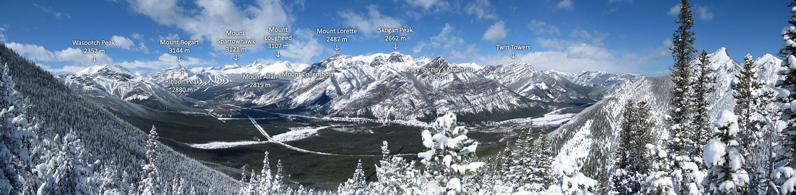
PAGE 9: HIDE PAGE 9SHOW/HIDE PIC 1SHOW/HIDE PIC 2

What a beautiful day it was and having fresh snow was bonus for me!! Mouseover for route and names.
PAGE 10: HIDE PAGE 10SHOW/HIDE PIC 1
After Phillipps Peak Attempt, two weeks ago, I though winter scramble was officially over but I still got to do one. Yay!!
PAGE 11: HIDE PAGE 11SHOW/HIDE PIC 1
According to my buddy, this ridge can offer juicy scrambling. Maybe next time.
PAGE 12: HIDE PAGE 12SHOW/HIDE PIC 1
Summit view.
PAGE 13: HIDE PAGE 13SHOW/HIDE PIC 1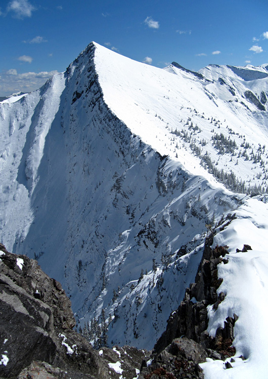
|
|
PAGE 14: HIDE PAGE 14SHOW/HIDE PIC 1
There was a slabby section around col, but by staying right up on edge, I could go forward even with snow condition.
PAGE 15: HIDE PAGE 15SHOW/HIDE PIC 1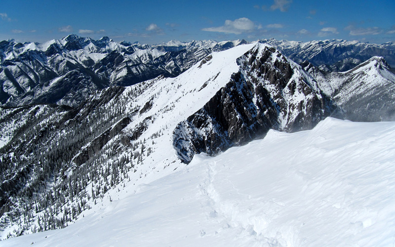
Looking back Midnight Peak from near summit.
PAGE 16: HIDE PAGE 16SHOW/HIDE PIC 1SHOW/HIDE PIC 2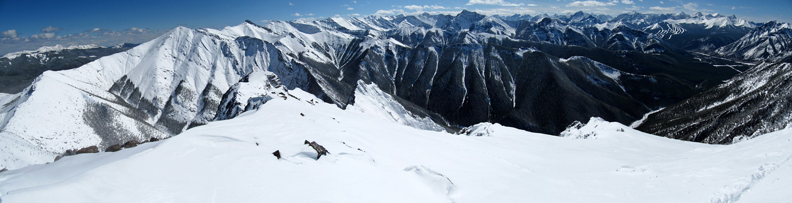

View from summit. Mouseover to see descent route. Both arrows lead to the same gully eventually.
PAGE 17: HIDE PAGE 17SHOW/HIDE PIC 1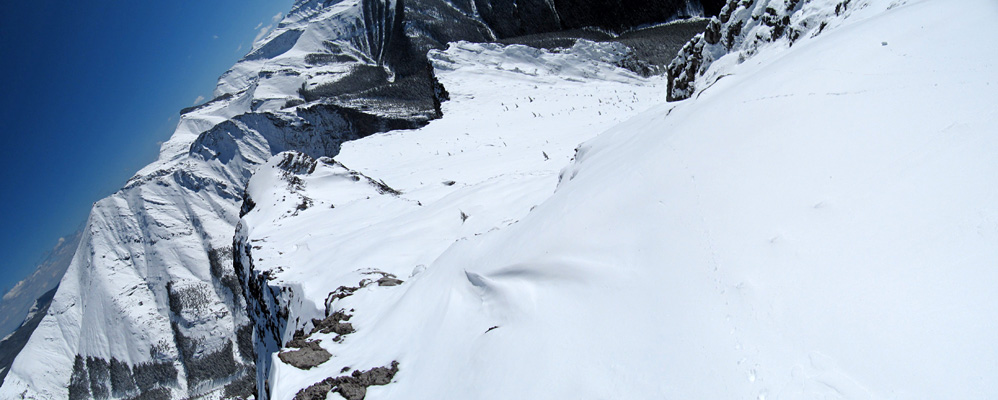
I was quite amazed with the sharp and steep ridge.
PAGE 18: HIDE PAGE 18SHOW/HIDE PIC 1
At waypoint "Waterfall". Impressive wall. Route finding becomes important from here.
PAGE 19: HIDE PAGE 19SHOW/HIDE PIC 1
Looking back descent gully/drainage.
PAGE 20: HIDE PAGE 20SHOW/HIDE PIC 1
This is winter. Hard to believe this area was pretty much dry a week ago.
PAGE 21: HIDE PAGE 21SHOW/HIDE PIC 1
There were few slabby part like this on the descent drainage. I had to bushwhack to avoid these.
PAGE 22: HIDE PAGE 22SHOW/HIDE PIC 1
Pretty.
PAGE 23: HIDE PAGE 23SHOW/HIDE PIC 1
Porcupine Creek. Bring waterproofed boots & gaiters to stay dry or bring speedo or bikini to let it all wet.
PAGE 24: HIDE PAGE 24SHOW/HIDE PIC 1
Mooooooon.