01

Gravenstafel Ridge to Mount Haig | 2010-07-24

Gravenstafel Ridge
  • Location: Castle-Crown Wildness
  • Activity: Scrambling
  • Height: 2,394 m (7,855 ft)
  • Elevation Gain: 950 m (3,117 ft)
  • Distance: 11.0 km / Round Trip (6.8 mi)
  • Avg Steepness: 9.8°
  • Estimated Time: 3.5-5 hrs
  • Technicality: Intermediate
  • Fitness Level: Moderate

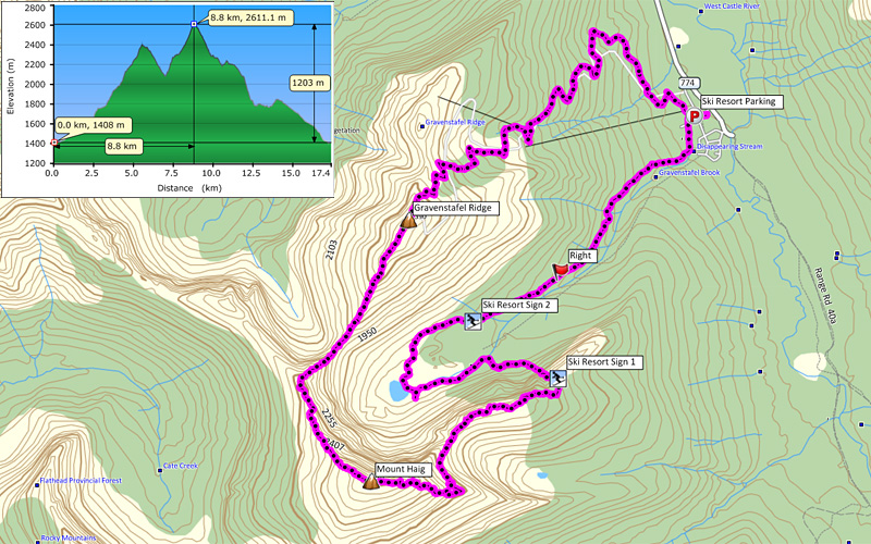
Above stats are for estimate to Gravenstafel Ridge and return the same way. For complete stats for this trip, please see page 4.

Nobody to cerebrate my birthday weekend scramble, I decided to go solo hikes. Ok ok ok, Andrea gave me wonderful Yukness and Shaun gave me awesome Carnarvon last week. (x_x☆ I had this special plan. When I saw Mount Haig for the first time back in 97, I wanted to summit it, but that desire never came true. When I found Nugara’s book covers Haig, I was so excited, and finally I made an opportunity to do it!

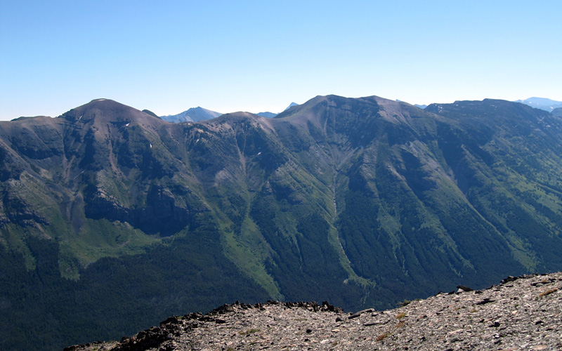
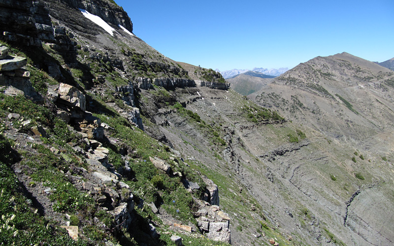
I parked my car at Castle Mountain Resort. From there I looked at ski hill map and picked “North Run” ski course for ascent. (Basically I did this backwards from Nugara’s route.) Walking on ski course made ascent very easy and I felt I was going very quick pace. Soon, I was at top of Gravenstafel Ridge. As simple as ascent of Gravenstafel was, Gravenstafel to Haig was simple as well. No route finding required, simply I stay on ridge. The dip between these two peaks was more than I hoped for but wasn’t too bad. If you don’t care Gravenstafel, then you can go to the lake then go up to the col between Gravenstafel and Haig. This way you don’t have to lose elevation. There are two ways to go to the lake. Either take a hiking/Quad trail (Nugara’s alternative descent route) or take “Cinch Traverse” ski course.

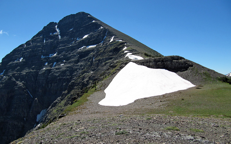
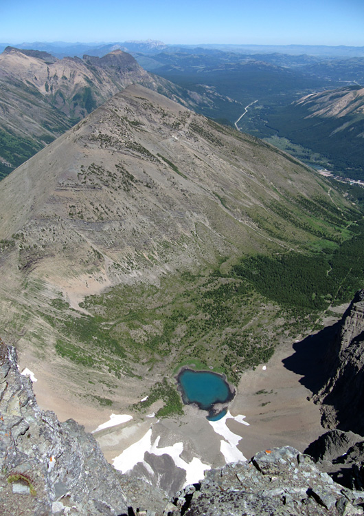
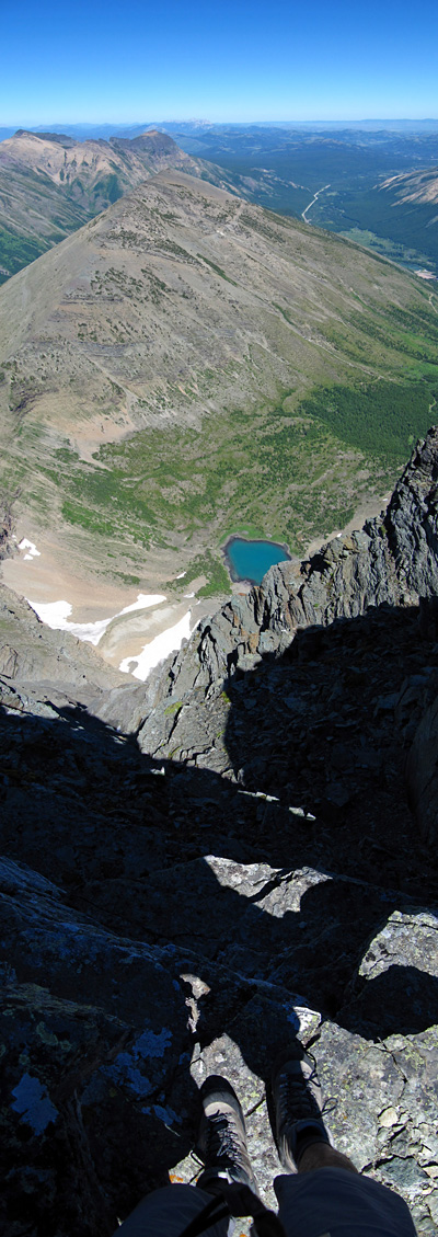
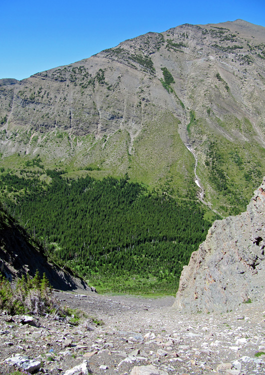
For descent I took little different approach from Nugara’s book. His route stays on the east ridge until almost at the treeline then get back to NE ridge. NE ridge is pretty much cliff with big rockbands near summit, so I still had to use east ridge, but as soon as I went low enough that I cleared most of the rockbands, I traversed to NE ridge, hoping this will minimize elevation loss (page 16). Most of rockbands on east ridge can be avoided by going right (south) but there was one rockband that was big and didn’t disappear unlike others. If you look for weaker spot, you maybe find moderate scramble, but I didn’t bother and took difficult scramble down climb (page 15). I also wanted to visit the lake so I took a scree terrain that I saw from Gravenstafel to get down. At the top of the gully there was avalanche danger sign (page 5 & 17). There were actually few of these signs along the ridge.

From the lake I decided to use “Cinch Traverse” ski course to get back to the parking lot because this route had more clearance so that I could enjoy the view longer. However there was no trail from the lake so about 1 km, you have to grasswhack til you find the course. I find a course sign at GR136641 (waypoint “Ski Resort Sign 2”).

02

Gravenstafel Ridge to Mount Haig | 2010-07-24

Green and summer.

03

Gravenstafel Ridge to Mount Haig | 2010-07-24

After the last ski lift. Summit of Gravenstafel Ridge was not too far.

04

Gravenstafel Ridge to Mount Haig | 2010-07-24

Barnaby Ridge's high point which I have done in 97. Mouse over for line.

People may wonder what is my history with Canada. I came here in 96 to 98 as a student. My high school in Tokyo made a study abroad program after graduation. That’s how I came to Canada. For the first year I stayed in Crowsnest Pass (CNP) with a host family which I call my Canadian family nowadays. During the stay in CNP, I had life changing event. That was outdoor education I had to take. The school hired a local outdoor guide Doug Wilson as the instructor. He introduced me backpacking, rock climbing, scrambling, canoeing etc, etc. A boy who grew up in Tokyo never was touched by nature before, this outdoor education was the rebirth of soistheman!! Unfortunately I had to leave the country, but the love of mountain never died. In 2006, I found a job in Calgary and came back to Canada for the second time. I purchased the best thing ever I bought, a car, in May of 08. Since then I have been mountains pretty much every weekends.

05

Gravenstafel Ridge to Mount Haig | 2010-07-24

Mount Haig
  • Location: Castle-Crown Wildness
  • Activity: Scrambling
  • Height: 2,618 m (8,590 ft)
  • Elevation Gain: 1,640 m (5,381 ft)
  • Distance: 17.4 km / Loop (10.8 mi)
  • Avg Steepness: 10.7°
  • Estimated Time: 7-10 hrs
  • Technicality: Advanced
  • Fitness Level: Athlete

Mouseover to see route.

06

Gravenstafel Ridge to Mount Haig | 2010-07-24

The dip at the col was deeper than I was hoping… o(T^T)o

07

Gravenstafel Ridge to Mount Haig | 2010-07-24

Gravenstafel on right. Looks like a pyramid. What's up with pyramid-like peaks lately… Let's see start with Pyramid Mountain, then Carnarvon… ok only 2.

08

Gravenstafel Ridge to Mount Haig | 2010-07-24

No difficulties.

09

Gravenstafel Ridge to Mount Haig | 2010-07-24

No name lake… Couldn't they name the lake "Haig Lake"?

10

Gravenstafel Ridge to Mount Haig | 2010-07-24

At the summit, looking north.

11

Gravenstafel Ridge to Mount Haig | 2010-07-24

Looking south.

12

Gravenstafel Ridge to Mount Haig | 2010-07-24

13 years of waiting was over!!

13

Gravenstafel Ridge to Mount Haig | 2010-07-24

Holy cow!! A cow!!

14

Gravenstafel Ridge to Mount Haig | 2010-07-24

Hot summer day, finally I was able to stay with shirts for most of the time!!

15

Gravenstafel Ridge to Mount Haig | 2010-07-24

Difficult down climb on east ridge. I didn't see this rockband die down, so I didn't bother look for a easier way out.

16

Gravenstafel Ridge to Mount Haig | 2010-07-24

Traversing from east ridge to NE ridge.

17

Gravenstafel Ridge to Mount Haig | 2010-07-24

Descent gully.

18

Gravenstafel Ridge to Mount Haig | 2010-07-24

I was hoping I could be naked and swim but there was a couple…

19

Gravenstafel Ridge to Mount Haig | 2010-07-24

Blue sky!

RETURN TO TOP
 
CLICK BLANK SPACE OR PRESS ESCAPE TO EXIT