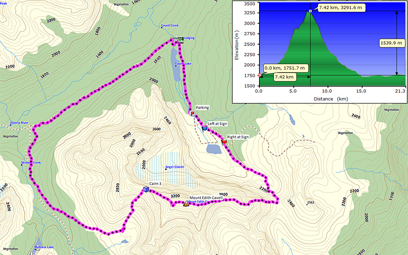
01
Mount Edith Cavell | 2013-08-11
Mount Edith Cavell
- Location: Jasper National Park
- Activity: Mountaineering
- Height: 3,363 m (11,034 ft)
- Elevation Gain: 1,605 m (5,266 ft)
- Distance: 21.4 km / Loop (13.3 mi)
- Avg Steepness: 8.5°
- Estimated Time: 11-15 hrs
- Technicality: Expert.III 5.3
- Fitness Level: Athlete
|
|
I'm somewhat back. I spent last several months in Tyria which put me so behind of my website updates.
Surprisingly Mount Edith Cavell is covered in 11,000er or Selected Alpine Climbs books but not in the scramble books. For scramblers who want to do another 11,000er beside Temple, this is it. West ridge route is nothing but moderate scramble with full of slog. Tasty.
To Col:
Navigating Cavell Meadows loop in the dark was little confusing but somehow we managed. About half way to the col, we lost the trail, so we were following GPS track which Dan's friend gave us. The most helpful and excellent route description ever!
East Ridge:
Once we were at the east ridge, continuous scrambling started. It is quite sustained steep difficult scrambling (page 5), some people may feel uncomfortable not using rope, however Dan and I both are Asians and we were ok because we can fly like kung fu masters in Chinese movies. Falling off, no problem!
Route wise stay right of the couloir. The couloir eventually pushed us right on the edge of cliff and then we had to walk on the snow ridge which was the top of the couloir (page 6). Here just in case we did use crampons for safety.
The Crux:
The crux would be either 5.3 pitch which comes after the ridge became flat for little distance (or sleeping at the parking lot knowing serac may come down on you any time while you are sleeping). We had a 40 m rope and did 1.5 pitches, so the 5.3 rock was probably around 50-60 m high (page 10 & 15).
To the Summit:
Towards the summit after the crux became easier but still had good amount of hands on scrambling. Summit ridge was rather flat and easy walk.
Descending West Ridge:
The most difficult part of descent was to figure out where exactly start to descent because if you descent too early you will be facing cliffs. Make things easy there was a trail and even more the biggest cairn I saw on Edith to indicate where to start descend at GR275361 (waypoint Cairn 3) which is close to col between high point GR271362 and the summit (AKA Cavell-Sorrow col). Enjoy the scree and long way out.
By the way we did bring bike for last 2 km on road! Which was great because not only it took 5 min to get to the car but at the same time we could take shower from wet road after rain.
02
Mount Edith Cavell | 2013-08-11
Dan not so happy after waking up at 2 am. Darn you thunderstorm forecast!
04
Mount Edith Cavell | 2013-08-11
Eventually we hit this snow slope to the col.
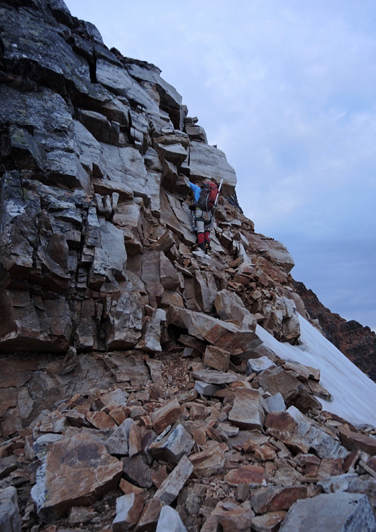
05
Mount Edith Cavell | 2013-08-11
Early stage of east ridge. Pretty much like this for entire time. If you are not confident then you should bring a MP3 player and listen to "I Believe I Can Fly" by R. Kelly while you scramble up. Though my personal choice would be "Falling Down the Mountain" by INXS.
06
Mount Edith Cavell | 2013-08-11
The top of couloir. We used crampons to be safe in case it's icy.
07
Mount Edith Cavell | 2013-08-11
Finally getting bright enough to take pictures… But by then we were so high already.
08
Mount Edith Cavell | 2013-08-11
More scrambles. Mount Fox used to be the No.1 peak for amount of hands on scrambling, but no longer. It's Edith now.
09
Mount Edith Cavell | 2013-08-11
Little break from scrambling.
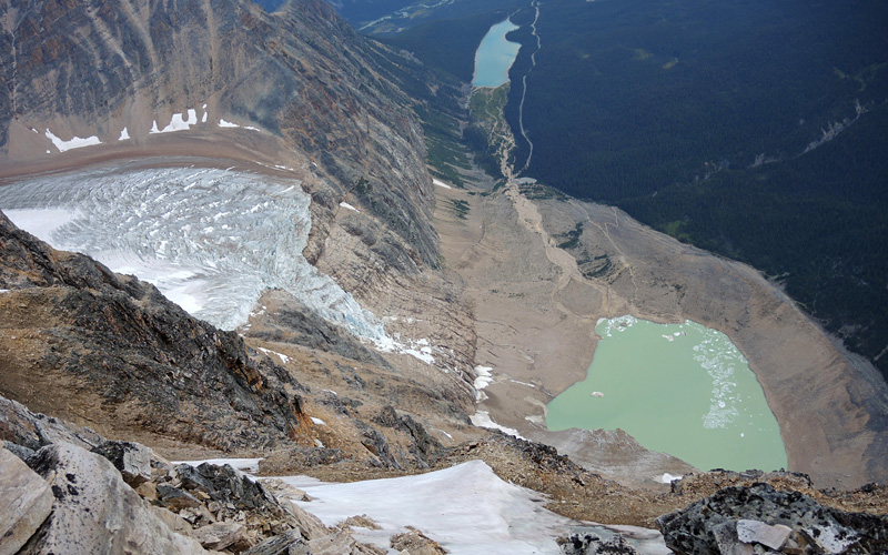
11
Mount Edith Cavell | 2013-08-11
Angel Glacier. According to a information board at the parking lot, the glacier broke off and destroyed parking lot last year should be close to where this picture was taken I believe.
13
Mount Edith Cavell | 2013-08-11
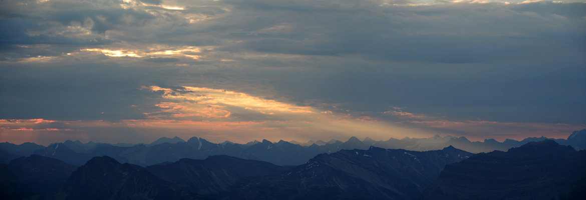
Bit cloudy in the morning.
14
Mount Edith Cavell | 2013-08-11
Looking down Angel Glacier and Cavell Lake.
16
Mount Edith Cavell | 2013-08-11
We didn't find any more spots we felt we need to use rope after the crux. If you are ok without rope until the crux, you may want to put the rope. Chances are you won't need rope. (Of course that can be depending on condition.) We didn't know so we short roped the rest of the way up.
17
Mount Edith Cavell | 2013-08-11
At the false summit. True summit isn't far from here.
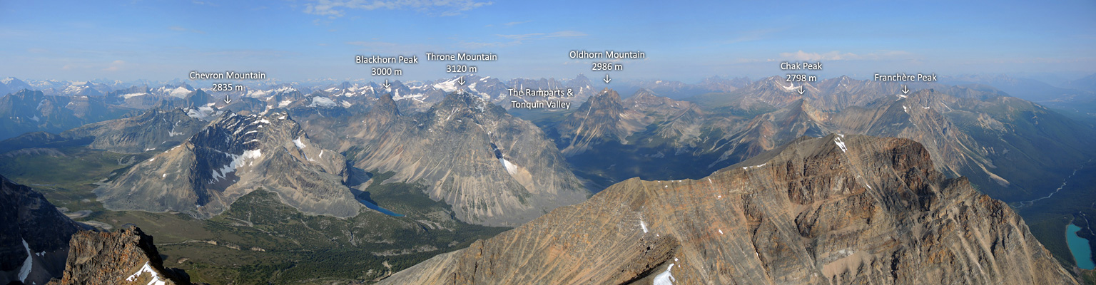
19
Mount Edith Cavell | 2013-08-11
Unfamiliar view. Jasper is so far. Mouseover for peak pointers.
20
Mount Edith Cavell | 2013-08-11
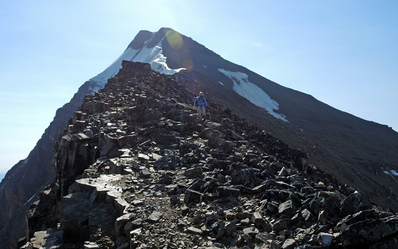
Following a trail on west ridge route.
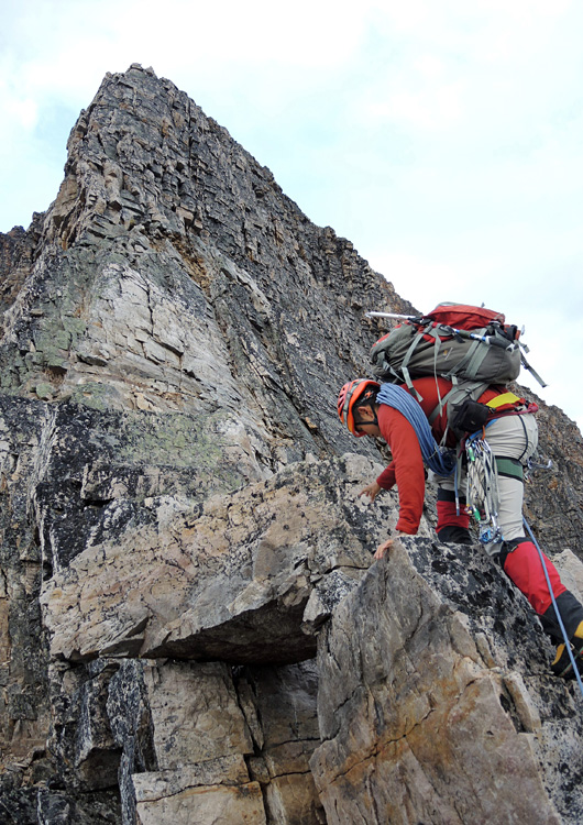
22
Mount Edith Cavell | 2013-08-11
We have met a solo scrambler who was taking west ridge approach.
23
Mount Edith Cavell | 2013-08-11
Don't be inpatient. As you can see if you start descending too early, there will be lots of cliffs.
24
Mount Edith Cavell | 2013-08-11
Now we have a long way back to the parking lot.


 SUBSCRIBE